EasyPlan Hi-Resolution Data
Introduction
In February 2000 the Space
Shuttle Endeavour scanned about 80% of the Earths total landmass, using radar,
to develop an accurate Digital Elevation Model (DEM). This data has recently
been published and is available to download. EasyPlan has been updated to read
these DEM files, and show the ground elevation in stunning detail. Even the
mine dumps around
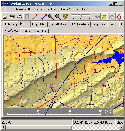
Comparison
The following pictures show
Hartbeespoort Dam rendered using the hi-resolution data, and using the existing
data.

Obtaining the high
resolution Digital Elevation Data
The DEM data can be obtained in two ways. In both cases your EasyPlan
subscription must be up-to-date. See Downloads for more info.
Option 1 : Downloading the
data yourself
1. Download EasyPlan version 3.030 or
later.
Downloaded
the DEM data for
Option 2 : Ordering from
EasyPlan
Alternatively a CD is
available for R200 (including VAT and postage to an address in SA) with the
latest Version of EasyPlan and the Hi Resolution digital elevation data. The
area covered is the whole of Southern Africa below 5 deg south.
PC Requirements for Hi-res
data
The following PC specifications are recommended
as a minimum:
- 2 GHz
Pentium
- 2 GB
free disk space
- 256
Meg RAM
- Display
1024x768 16 bit colour
- Windows
98, NT, ME, 2000 or XP
Hi-Res data not displaying?
![]() The files should be in c:\Program
Files\EasyPlan\EasyPlan3\Dem
The files should be in c:\Program
Files\EasyPlan\EasyPlan3\Dem
![]() They must be unzipped and have a “.hgt”
extension
They must be unzipped and have a “.hgt”
extension
![]() Files must have the "Read
Only" flag cleared.
Files must have the "Read
Only" flag cleared.
![]() You must be using EasyPlan version 3.030
or later
You must be using EasyPlan version 3.030
or later
![]() Enable "Hi Definition
Elevation" in "Units & Preferences" "Map"
Enable "Hi Definition
Elevation" in "Units & Preferences" "Map"
![]() Move the slider on the map page to about
the middle
Move the slider on the map page to about
the middle
![]() The file name refers to the bottom left
corner of the block
The file name refers to the bottom left
corner of the block
![]() You need only download and unzip the
tiles covering the area of interest
You need only download and unzip the
tiles covering the area of interest